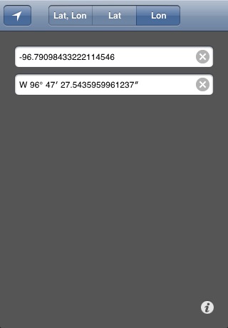
iLatLon™ is GIS utility application that converts a geographic coordinate, a latitude or a longitude between decimal degrees, DMS (degrees, minutes, seconds) and DM (degrees, minutes) formats.
Features:
- Single entry: automatic recognition and parsing of the entered format.
- Simple copy and paste exchange of data with other applications.
- High conversion precision: up to 13 digits after the decimal point for all supported formats.
- Conversion of the entire geographic coordinate, or its component only: latitude or longitude.
- Determines geographic coordinate of the current location
- Support of (3) geographic coordinate formats: DD (decimal degrees), DMS (degrees, minutes, seconds), and DM (degrees, minutes). Total of 22 format variations.
How to use it:
Click on the appropriate segment on the top of the main window to indicate what you want to convert - geographic coordinate (lat, lon), latitude (lat) or longitude (lon).
In the first field, enter a geographic coordinate, latitude or longitude in the DD, DMS or DM format, if the entry matches one of the supported formats then the second field will display the result, otherwise it will display "Invalid entry". The default result format is DMS. To change the result format and precisions press information icon in the right bottom or top corner of the main window.
Examples of the recognized geographic coordinate formats:
DD (decimal degrees) format: 34.848735, -122.03118
DMS (degrees, minutes, seconds) format: 34 50 55.446 N, 122 1 52.25 W
DM (degrees, minutes) format: N34 50.9241, W122 1.8708
To acquire the geographic coordinate, latitude or longitude of your current location press the the tracking button (white arrow) in the left top corner of the main window.


